
The Point: Southern Ohio's Premiere Industrial Park
Home > Map
The Point: Map of the Point
Excellent Sites Available
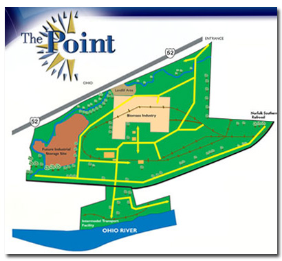
The Point encompasses 504 acres of prime, flat land with river, rail and highway access. It is utility-ready and has 3,400 ft. of Ohio River frontage with an intermodal transport dock facility. Seven miles of rail track runs through the site for easy connection to Norfolk Southern rail lines. U.S. 52 runs beside the property with I-64 only 6 miles away from the site’s entrance.
New and existing buildings and storage tanks are throughout the site and are available for immediate occupancy. Large and small tracks of cleared, flat prime land are available and may be sub-divided. For more information or a tour, call our office at (800) 408-1334.
The ideal site location would have river frontage with barge loading capabilities, a major railroad line running right beside it, and an interstate and highway system at its entrance. Look no more, The Point has it all.
The Point’s ideal location offers many competitive advantages for companies wanting to locate, expand or relocate their operations. The Point is a multi-modal center with direct access to railroad, highway, air and river transportation.
The Point Industrial Park 216 Collins Avenue South Point, Ohio 45680-0488 Telephone: (855) FTZ-PORT - (855) 389-7678
© Copyright 2011 The Point Industrial Park